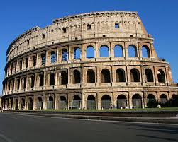
 The Colosseum or Roman Coliseum, originally the Flavian Amphitheatre (Latin: Amphitheatrum Flavium, Italian Anfiteatro Flavio or Colosseo), is an elliptical amphitheatre in the center of the city of Rome, Italy, the largest ever built in the Roman Empire. It is one of the greatest works of Roman architecture and Roman engineering. Occupying a site just east of the Roman Forum, its construction started between 70 and 72 AD under the emperor Vespasian and was completed in 80 AD under Titus, with further modifications being made during Domitian's reign (81–96).The name "Amphitheatrum Flavium" derives from both Vespasian's and Titus's family name (Flavius, from the gens Flavia).
Capable of seating 50,000 spectators, the Colosseum was used for gladiatorial contests and public spectacles. As well as the gladiatorial games, other public spectacles were held there, such as mock sea battles, animal hunts, executions, re-enactments of famous battles, and dramas based on Classical mythology. The building ceased to be used for entertainment in the early medieval era. It was later reused for such purposes as housing, workshops, quarters for a religious order, a fortress, a quarry, and a Christian shrine.
It has been estimated that about 500,000 people and over a million wild animals died in the Colosseum games.
Although in the 21st century it stays partially ruined due to damage caused by devastating earthquakes and stone-robbers, the Colosseum is an iconic symbol of Imperial Rome and its breakthrough achievements in earthquake engineering. It is one of Rome's most popular tourist attractions and still has close connections with the Roman Catholic Church, as each Good Friday the Pope leads a torchlit "Way of the Cross" procession around the various levels of the amphitheatre.
The Colosseum is also depicted on the Italian version of the five-cent euro coin.


History
Ancient
Construction of the Colosseum began under the rule of the Emperor Vespasian in around 70–72AD. The site chosen was a flat area on the floor of a low valley between the Caelian, Esquiline and Palatine Hills, through which a canalised stream ran. By the 2nd century BC the area was densely inhabited. It was devastated by the Great Fire of Rome in AD 64, following which Nero seized much of the area to add to his personal domain. He built the grandiose Domus Aurea on the site, in front of which he created an artificial lake surrounded by pavilions, gardens and porticoes. The existing Aqua Claudia aqueduct was extended to supply water to the area and the gigantic bronze Colossus of Nero was set up nearby at the entrance to the Domus Aurea.
Although the Colossus was preserved, much of the Domus Aurea was torn down. The lake was filled in and the land reused as the location for the new Flavian Amphitheatre. Gladiatorial schools and other support buildings were constructed nearby within the former grounds of the Domus Aurea. According to a reconstructed inscription found on the site, "the emperor Vespasian ordered this new amphitheatre to be erected from his general's share of the booty." This is thought to refer to the vast quantity of treasure seized by the Romans following their victory in the Great Jewish Revolt in 70AD. The Colosseum can be thus interpreted as a great triumphal monument built in the Roman tradition of celebrating great victories. Vespasian's decision to build the Colosseum on the site of Nero's lake can also be seen as a populist gesture of returning to the people an area of the city which Nero had appropriated for his own use. In contrast to many other amphitheatres, which were located on the outskirts of a city, the Colosseum was constructed in the city centre; in effect, placing it both literally and symbolically at the heart of Rome.
The Colosseum had been completed up to the third story by the time of Vespasian's death in 79. The top level was finished and the building inaugurated by his son, Titus, in 80. Dio Cassius recounts that over 9,000 wild animals were killed during the inaugural games of the amphitheatre. The building was remodelled further under Vespasian's younger son, the newly-designated Emperor Domitian, who constructed the hypogeum, a series of underground tunnels used to house animals and slaves. He also added a gallery to the top of the Colosseum to increase its seating capacity.
In 217, the Colosseum was badly damaged by a major fire (caused by lightning, according to Dio Cassius) which destroyed the wooden upper levels of the amphitheatre's interior. It was not fully repaired until about 240 and underwent further repairs in 250 or 252 and again in 320. An inscription records the restoration of various parts of the Colosseum under Theodosius II and Valentinian III (reigned 425–450), possibly to repair damage caused by a major earthquake in 443; more work followed in 484 and 508. The arena continued to be used for contests well into the 6th century, with gladiatorial fights last mentioned around 435. Animal hunts continued until at least 523.
Medieval
The Colosseum underwent several radical changes of use during the medieval period. By the late 6th century a small church had been built into the structure of the amphitheatre, though this apparently did not confer any particular religious significance on the building as a whole. The arena was converted into a cemetery. The numerous vaulted spaces in the arcades under the seating were converted into housing and workshops, and are recorded as still being rented out as late as the 12th century. Around 1200 the Frangipani family took over the Colosseum and fortified it, apparently using it as a castle.
Severe damage was inflicted on the Colosseum by the great earthquake in 1349, causing the outer south side, lying on a less stable alluvional terrain, to collapse. Much of the tumbled stone was reused to build palaces, churches, hospitals and other buildings elsewhere in Rome. A religious order moved into the northern third of the Colosseum in the mid-14th century and continued to inhabit it until as late as the early 19th century. The interior of the amphitheatre was extensively stripped of stone, which was reused elsewhere, or (in the case of the marble façade) was burned to make quicklime. The bronze clamps which held the stonework together were pried or hacked out of the walls, leaving numerous pockmarks which still scar the building today.
Modern
During the 16th and 17th century, Church officials sought a productive role for the vast derelict hulk of the Colosseum. Pope Sixtus V (1585–1590) planned to turn the building into a wool factory to provide employment for Rome's prostitutes, though this proposal fell through with his premature death. In 1671 Cardinal Altieri authorized its use for bullfights; a public outcry caused the idea to be hastily abandoned.
In 1749, Pope Benedict XIV endorsed as official Church policy the view that the Colosseum was a sacred site where early Christians had been martyred. He forbade the use of the Colosseum as a quarry and consecrated the building to the Passion of Christ and installed Stations of the Cross, declaring it sanctified by the blood of the Christian martyrs who perished there (see Christians and the Colosseum). However there is no historical evidence to support Benedict's claim, nor is there even any evidence that anyone prior to the 16th century suggested this might be the case; the Catholic Encyclopedia concludes that there are no historical grounds for the supposition. Later popes initiated various stabilization and restoration projects, removing the extensive vegetation which had overgrown the structure and threatened to damage it further. The façade was reinforced with triangular brick wedges in 1807 and 1827, and the interior was repaired in 1831, 1846 and in the 1930s. The arena substructure was partly excavated in 1810–1814 and 1874 and was fully exposed under Benito Mussolini in the 1930s.
18 September 2009
Colosseum
Temple of Zeus
 The Temple of Zeus at Olympia, built in 470-456 BC, was the ancient Greek temple in Olympia, Greece, dedicated to the chief of the gods, Zeus. It was the very model of the fully-developed classical Greek temple of the Doric order.The temple stood in the most famous sanctuary of Greece, which had been dedicated to local and Pan-Hellenic deities and had probably been established towards the end of the Mycenaean period. The Altis, the enclosure with its sacred grove, open-air altars and the tumulus of Pelops, was first formed during the tenth and ninth centuries BCE, when the cult of Zeus joined the established cult of Hera.
It housed the cult statue of Zeus which was one of the Seven Wonders of the Ancient World. The Chryselephantine statue was approximately 13 m (43 ft) high and was made by the sculptor Phidias in his workshop on the site at Olympia. He took about twelve years to complete it. On his head was a sculpted wreath of olive sprays. In his right hand he held a figure of Nike, the goddess of victory, also made from ivory and gold, and in his left hand, a scepter made with many kinds of metal, with an eagle perched on the top. His sandals were made of gold and so was his robe. His garments were carved with animals and with lilies. The throne was decorated with gold, precious stones, ebony, and ivory. The statue was the most famous artistic work in Greece.
The temple was constructed by the architect Libon, with carved metopes and triglyph friezes, topped by pediments filled with sculptures in the Severe Style, now attributed to the Olympia Master and his studio.
The main structure of the building was of a local limestone that was unattractive and of poor quality, and so it was coated with a thin layer of stucco to give it an appearance of marble. All the sculptural decoration on the temple was made of Parian marble, and the roof tiles were of the same Pentelic marble used to build the Parthenon at Athens.


The unifying theme of iconography of the temple is the dike or justice based on custom, as represented by Zeus, its upholder.
The east pediment, erroneously attributed to Paeonius by Pausanias, who gave a detailed account of its sculptures in the late second century CE, depicted the myth of the chariot race between Pelops and Oenomaus, with Zeus standing in the centre, flanked by standing pairs of heroes and heroines, and the two chariot groups, with recumbent figures in the corners. Hippodameia and her maid stand to Zeus' left (north), and Pelops to Zeus' right. A great part of all fifteen figures has been recovered, in carefully documented excavations; scholars still discuss the placement and interrelationships of six seated or kneeling figures in the composition, and their specific identifications.
The west pediment depicted the Centauromachy, the fight at the wedding of Peirithoos between the Lapiths and the centaurs, who had violated xenia, the sacred rules of hospitality that support the social norms. Apollo stood in the centre, flanked by Peirithoos and Theseus. The Lapiths have been taken to represent the civilised Olympian order of the Greeks themselves, while the Centaurs represent primitive nature of chthonic beings; the frieze also reminded fifth-century Greeks of their victory over the Persians, "outsider" threateners of the Hellenic order. The statue of Apollo (currently in the Olympia Archaeological Museum) was depicted on the obverse of the Greek 1000 drachmas banknote of 1987-2001.
The pronaos and opisthodomos, the entrance portico and the balancing false portico at the rear, were constructed in antis, with six metopes at either end, carved with the 12 labours of Heracles, in which Heracles successfully defeats a series of creatures and monsters that threaten righteous order.
The Roman general Mummius dedicated twenty-one gilded shields after he sacked Corinth in 146 BCE; they were hung upon the columns. In 426 CE, Theodosius II ordered the destruction of the sanctuary, and earthquakes in 522 and 551 devastated the ruins and left the Temple of Zeus partially buried.
The site of the ancient sanctuary, long forgotten under landslips and flood siltation, was identified in 1766. In 1829 a French team partially excavated the Temple of Zeus, taking several fragments of the pediments to the Musée du Louvre. Systematic excavation began in 1875, under the direction the German Archaeological Institute, and has continued, with some interruptions, to the present time.
17 September 2009
Rockfort Ucchi Pillayar Temple
 Rockfort or Ucchi Pillayar koil, is a combination of two famous 7th century Hindu temples, one dedicated to Lord Ganesh and the other dedicated to Lord Shiva, located a top of a small rock in Trichy, India. Geologically the 83m high rock is said to be one of the oldest in the world, dating over 3 billion years ago, and mythologically this rock is the place where Lord Ganesh ran from King Vibishana, after establishing the Ranganathaswamy deity in Srirangam.


Etymology
The name rock fort comes from the fact that the place was used for military fortification first by the Vijayanagar emperors and later by the British during the Carnatic wars
Architecture
The Rock Fort temple stands 83m tall perched atop the rock. The smooth rock was first cut by the Pallavas but it was the Nayaks of Madurai who completed both the temples under the Vijayanagara empire.
The temple complex is composed of two parts: a Shiva temple (Thayumanaswamy) carved in the middle of the rock and a Pillayar (Ganesh)temple at the top portion of the rock[1]. The Shiva temple is the bigger one, housing a massive stone statue of Shiva in the form of Linga along with a separate sanctum for goddess Parvati. The temple is mystic in its nature with an awe-inspiring rock architecture. The Ganesh temple is much smaller with an access through steep steps carved on the rock and provides a stunning view of Trichy, Srirangam and the rivers Kaveri and Kollidam. Due to its ancient and impressive architecture created by the Pallavas, the temple is maintained by the Archaeological department of India.
Mythology of the Vinayaka temple
Vibhishana, was the younger brother of the Asura King Ravana who ruled Lanka (now known as Srilanka). Lord Rama in the epic of Ramayana rescues his wife Sita, who was kidnapped and held by Ravana, with the help of Sugriva and Hanuman defeated him. In this war, the moral and truth-abiding brother of Ravana, Vibishana aids Rama in his battle against his brother. Ultimately Rama wins the war and as a token of love, He gifts Vibishana an Idol of Lord Ranganatha, a form of Vishnu.
Vibhishana, though he supported Rama, was basically an Asura, hence the Devas (who are arch rivals to Asuras as per Hindu mythology) wanted to stop this idea of an Asura taking Lord's supreme form to his Kingdom. They request the help of the God of Happiness, Lord Vinayaka and the Lord accepts the plan. Vibhishana, while on his back to his Kingdom, goes through Trichi, and wanted to take his bath in the river Kaveri and do his daily rituals. However, he is perplexed as the idol once kept in land, can never be removed and has to be in that place forever.
As a solution, Vibishana tries to find someone to hold the idol while he was taking bath and finds the Lord Vianayaka under disguise of a cowherd boy. As per the plan, when Vibishana is fully into water, Vinayaka takes the statues and keeps it firmly in sand, in the banks of kaveri. On seeing this, the angry Vibhishana chases the boy, to punish him, and boy keeps running and climbs over the rock near the Kaveri bank. Vibhishana finally reaches the boy and hits him on the fore-head of little boy who then reveals himself to be Vinayaga. Vibishana immediately apoligizes and the Lord gives him his blessings and sends him off to Lanka.
The place on which the Ranganathan idol was kept was later covered in deep forests, due to disuse and after a very long time, it is discovered when a Chola king chasing a parrot finds the idol accidentally. He then establishes the Ranganathaswamy temple,Srirangam as one of the largest temple complexes in the world. Meanwhile, the Pallavas built the Vinayaka temple and the Thayumanaswamy temple, in the rock which Vinayaka uses to escape Vibishana.
16 September 2009
Flying pterosaurs runway Found
 The scientists found a foundation that allegedly flew to the prehistoric reptiles that have been long extinct, aka pterosaur pterosaurs beach shore. Platform was located in a lagoon in southwest France and allegedly was used by the extinct animals from 140 million years ago. From the results indicate footprints tread marks pterosaur or pterodactyloid, prehistoric reptiles that had wings as wide as three feet or four feet. Flying reptiles such as using a nail penumpu then take gradual steps to land and assisted by a little jump with both feet, and ends with using the hand brake.
One of Paleontology at the University of Berkeley, California, United States, said Kevin grains no other animal-shaped making tracks in the world pterosaurs foot when about to take off or landing.
In fact, continued grains, pterosaurs did have a great ability to fly, where he could control the beating of wings. Researchers are expected in the future are better able to uncover traces left by these flying reptiles, and can provide an explanation of how the prehistoric flying creature that has long extinct. "There are hundreds of footprints are visible in this hunt," he said as quoted by LiveScience grains, recently.


However, a rebuttal statement from an expert at the Institute of Fossil Animals and Study Center for Ancient Man in Beijing, China, David Hone. "Pterosaurs like birds in general, very light weight and do not always leave a trail when compared to a sauropod weighing 50 tons."
"If the trail can be traced from the pterosaurs, as well as seeing impressions in soft mud or sand. But pterosaurs discovered the landing track is an interesting thing," added Hone again. He also said that if the discovery of the researchers on the landing point pterosaurs very convincing.
Dinosaurs
 Dinosaurs (Greek: δεινόσαυρος, deinosauros) were the dominant vertebrate animals of terrestrial ecosystems for over 160 million years, from the late Triassic period (about 230 million years ago) until the end of the Cretaceous period (65 million years ago), when most of them became extinct in the Cretaceous–Tertiary extinction event. The 10000 living species of birds may be classified as dinosaurs.
The term "dinosaur" was coined in 1842 by Sir Richard Owen and derives from Greek δεινός (deinos) "terrible, powerful, wondrous" + σαῦρος (sauros) "lizard". It is sometimes used informally to describe other prehistoric reptiles, such as the pelycosaur Dimetrodon, the winged pterosaurs, and the aquatic ichthyosaurs, plesiosaurs and mosasaurs, although none of these animals were dinosaurs. Through the first half of the 20th century, most of the scientific community believed dinosaurs to have been slow, unintelligent cold-blooded animals. Most research conducted since the 1970s, however, has supported the view that dinosaurs were active animals with elevated metabolisms and numerous adaptations for social interaction. The resulting transformation in the scientific understanding of dinosaurs has gradually filtered into popular consciousness.
The 1861 discovery of the primitive bird Archaeopteryx first suggested a close relationship between dinosaurs and birds. Aside from the presence of fossilized feather impressions, Archaeopteryx was very similar to the contemporary small predatory dinosaur Compsognathus. Research has since identified theropod dinosaurs as the most likely direct ancestors of birds; most paleontologists today regard birds as the only surviving dinosaurs, and some suggest that dinosaurs and birds should be grouped into one biological class.[1] Aside from birds, crocodilians are the only other close relatives of dinosaurs to have survived until the present day. Like dinosaurs and birds, crocodilians are members of Archosauria, a group of reptiles that first appeared in the very late Permian and came to predominate in the mid-Triassic.
Since the first dinosaur fossils were recognized in the early nineteenth century, mounted dinosaur skeletons have become major attractions at museums around the world. Dinosaurs have become a part of world culture and remain consistently popular. They have been featured in best-selling books and films (notably Jurassic Park), and new discoveries are regularly covered by the media.


Osorezan (Mount Osore)
 Osorezan (Mount Osore) is ranked along with Koyasan and Hieizan as one of Japan's three most sacred places. It was discovered over 1000 years ago by a Buddhist priest in search of a sacred mountain that resembles the world of Buddha. Today, it is the site of Bodaiji Temple. Osorezan is translated as "Fear Mountain", a name that comes in part from the mountain's exceptional landscape. The area is rich in volcanic activity, and a strong smell of sulfur permeates the air. The ground is gray and barren and marked by openings that steam, bubble and blow hot water. Lake Usori, located next to the temple, is colored various shades of blue due to its high sulfur content.
Osorezan is also known as entrance to afterlife, because it features geographical elements similar to descriptions of Buddhist hell and paradise, including eight surrounding peaks and a river, Sanzu no Kawa, which has to be crossed by all dead souls on their way to afterlife and is often compared to the River Styx of ancient Greek mythology.
Among the souls trying to cross the river are the souls of dead children and unborn babies who build piles of pebbles along the riverbed (Sai no Kawara) in an attempt to get to the other side. They are supported by Jizo, a popular bodhisattva of Japanese Buddhism, who protects the souls from evil demons, which constantly try to destroy the piles of pebbles.
Statues of Jizo are commonplace around Osorezan, as are piles of stones and pebbles. The pebbles are offerings to Jizo by parents of dead children in the hope that he will use the stones to help their children gain access to paradise. Brightly colored toy windmills are another common offering frequently seen around Osorezan's grounds.
Every year, Bodaiji's festival (July 22 to 24) attracts the bereaved and those hoping to communicate with lost loved ones through mediums, known as Itako. Itako are blind women who have undergone extensive spiritual training. In order to commune with the dead, they perform austere purification rituals for three months prior to the event and enter into a deep, prolonged trance during the festival.
Although access can be a challenge due to the lack of public transportation, Osorezan is a well known destination and the temple is equipped with overnight lodgings for guests. Both overnight and day visitors to the temple can use the simple hot spring baths located on the temple grounds.
Walking paths crisscross Bodaiji's unique temple grounds, affording visitors plenty of opportunity to stroll around the site and take in the scenery. A walk along the shores of Lake Usori is recommended, although visitors should avoid the poisonous water.
The Shiten'no-ji Temple

The Shiten'no-ji Temple was built late in the 6th century by Shotoku-taishi (Prince Shotoku), a son of Emperor Yomei, as a token of his gratitude to the Four Devas (Shi-tenno), the guardians for Buddhism and Buddhists, for responding to his prayer to let him overthrow Mononobe-no-Moriya, an anti-Buddhist administrator, in the 6th century.
With its middle gate, tower, main hall and lecture hall arrangned from south to north in a beeline, which is known as "Shiten'no-ji type temple layout" modeled after the then Chinese style of architecture, the Shiten'no-ji Temple typifies the Buddhist structures built in the Asuka Period from the late 6th century through the early 7th century together with the Horyu-ji Temple, a World Cultural Heritage, in Nara. Soon afer its erection, the temple had a free dispensary (Seyaku-in) and other welfare facilities set up in its precincts to give the poor free medicines and treatment and provide free accommodations for the aged without family and infants, opening the way to public welfare service in Japan.
In January, there is "Doya-Doya," a festival in which the young scramble for paper charms. Autumn is the time when "Shiten'no-ji Wasso, " a festival reproducing a bit of the history of cultural interchange between the ancient Korean Peninsula and Japan, takes place.
Temple Mount
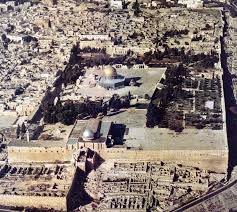 The Temple Mount (Hebrew: הַר הַבַּיִת, Har haBáyit), also known as Mount Moriah and by Muslims as the Noble Sanctuary (Arabic: الحرم القدسي الشريف, al-haram al-qudsī ash-sharīf), is a religious site in the Old City of Jerusalem. Due to its importance for Judaism and Islam it is one of the most contested religious sites in the world.
The Temple Mount contains the holiest site in Judaism. Jewish Midrash holds that it was from here that the world expanded into its present form, and that this was where God gathered the dust he used to create the first man, Adam. The Torah records that it was here that God chose to rest His Name and Divine Presence, and consequently two Jewish Temples were built at the site. According to Jewish tradition, the Third Temple will also be located here, and will be the final one. In recent times, due to difficulties in ascertaining the precise location of the Mount's holiest spot, many Jews will not set foot on the Mount itself.
The Noble Sanctuary is the third holiest site in Islam, revered as the destination of Muhammad's journey to Jerusalem, and the location of his ascent to heaven. The site is also associated with all the Jewish biblical prophets who are also revered in Islam. The site is the location of the al-Aqsa Mosque and the Dome of the Rock, the oldest extant Islamic structure in the world.[1]
Controlled by Israel since 1967, both Israel and the Palestinian Authority claim sovereignty over the site, which remains a key issue in the Arab-Israeli conflict. A Muslim council, known as the Muslim Waqf, manages the site. The Israeli government enforces a controversial ban on prayer by non-Muslim visitors.
History
Early history
The hill is believed to have been inhabited since the 4th millennium BCE. Its southern section was walled at the beginning of the 2nd millennium BCE, in around 1850 BCE, by Canaanites who established a settlement there named Jebus. It was this city that King David captured in around 1000 BCE and renamed the City of David.David intended to build a sanctuary to God, as the first temple of the Israelites in Jerusalem, outside the city walls on the northern edge of the hill. He purchased the area, which the Bible refers to as Mount Moriah, from Araunah who owned the site. David's son Solomon completed the task of erecting the First Temple at the site in 960 BCE. Solomon’s Temple was destroyed by Nebuchadnezzar II of Babylon in 586 BCE.
Achaemenid Persian, Hasmonean periods, and Herod’s expansion
Much of the Mount's early history is synonymous with events pertaining to the Temple itself. After the destruction of Solomon’s Temple by Nebuchadnezzar II of Babylon in 586 BCE, construction of the Second Temple is understood to have begun under Cyrus in around 538 BCE, and completed in 516 BCE. Evidence of a Hasmonean expansion of the Temple Mount has been recovered by archaeologist Leen Ritmeyer. Around 19 BCE, Herod the Great further expanded the Mount and rebuilt the temple. The ambitious project, which involved the employment of 10,000 workers, more than doubled the size of Temple Mount to approximately 36 acres (150,000 m2). Herod leveled the area by cutting away rock on the northwest side and raising the sloping ground to the south. He achieved this by constructing huge buttress walls and vaults, filling the necessary sections with earth and rubble. In addition to restoration of the Temple, its courtyards, and porticoes, Herod also built Antonia Fortress abutting the northwestern corner of the Temple Mount, and a rainwater reservoir, Birket Israel, in the northeast. As a result of the First Jewish-Roman War, the fortress was destroyed by Roman emperor Vespasian, in 70 CE, under the command of his son and imperial heir, Titus.
Middle Roman period
The city of Aelia Capitolina was built in 130 CE by the emperor Hadrian, and occupied by a Roman colony on the site of Jerusalem, which was still in ruins from the First Jewish Revolt in 70 CE.
Aelia came from Hadrian's nomen gentile, Aelius, while Capitolina meant that the new city was dedicated to Jupiter Capitolinus, to whom a temple was built on the site of the former second Jewish temple, the Temple Mount.
Hadrian had intended the construction of the new city as a gift to the Jews, but since he had constructed a giant statue of himself in front of the Temple of Jupiter and the Temple of Jupiter had a huge statue of Jupiter inside of it, there were now two enormous graven images on the Temple Mount. It was also the normal practice of the adherents of the Hellenic religion to sacrifice pigs before their deities. In addition to this, Hadrian issued a decree prohibiting the practice of circumcision. These three factors, the graven images, the sacrifice of pigs before the altar, and the prohibition of circumcision, constituted for non-Hellenized radical Zealot Jews a new abomination of desolation, and thus Bar Kochba launched the Third Jewish Revolt. After the Third Jewish Revolt failed, all Jews were forbidden on pain of death from entering the city.
Late Roman period
About 325 it is believed that Constantine's mother, St. Helena, built a small church on the Mount in the 4th century, calling it the Church of St. Cyrus and St. John, later on enlarged and called the Church of the Holy Wisdom. The church was later destroyed and on its ruins the Dome of the Rock was built. Since it is known that Helena ordered the Temple of Venus to the west of the Temple Mount to be torn down to construct the Church of the Holy Sepulchre, presumably she also ordered the Temple of Jupiter on the Temple Mount to be torn down to construct the Church of St. Cyrus and St. John.
Byzantine period
Archaeological evidence in the form of an elaborate mosaic floor similar to the one in the Church of the Nativity in Bethlehem and multiple fragments of an elaborate marble Templom (chancel screen) prove that an elaborate Byzantine church or monastery stood on the Temple Mount in Byzantine times, presumably the aforementioned Holy Wisdom Church.
Sassanid vassal state period
Caliph Omar ordered a mosque to be constructed at the southeast corner, facing Mecca, near which the al-Aqsa Mosque was built 78 years later. The original building is now known to have been wooden and to have been constructed on the site of a Byzantine church with an elaborate mosaic floor. (The Persian conquest that immediately preceded the Arab conquest makes it uncertain who destroyed the church.)
In 691 an octagonal Muslim building topped by a dome was built by the Caliph Abd al Malik around the rock, for political reasons, in violation of the Caliph Omar's teachings. The shrine became known as the Dome of the Rock (Qubbat as-Sakhra قبة الصخرة). The dome itself was covered in gold in 1920. In 715 the Umayyads led by the Caliph al-Walid I, rebuilt the Temple's nearby Chanuyos into a mosque (see illustrations and detailed drawing) which they named al-Masjid al-Aqsa المسجد الأقصى, the al-Aqsa Mosque or in translation "the furthest mosque", corresponding to the Muslim belief of Muhammad's miraculous nocturnal journey as recounted in the Quran and hadith. The term al-Haram al-Sharif الحرم الشريف (the Noble Sanctuary) refers to the whole area that surrounds that Rock as was called later by the Mamluks and Ottomans.
The structures have been ruined or destroyed several times in earthquakes;[citation needed] the current version dates from the first half of the 11th century. For Muslims, the importance of the Dome of the Rock and al-Aqsa Mosque makes Jerusalem the third-holiest city, after Mecca and Medina. The mosque and shrine are currently administered by a Waqf (an Islamic trust).
In 1867, a team from the Royal Engineers, led by Lieutenant Charles Warren (later the London police commissioner of Jack the Ripper fame) and financed by the Palestine Exploration Fund (P.E.F.), discovered a series of tunnels beneath Jerusalem and the Temple Mount, some of which were directly underneath the headquarters of the Knights Templar. Various small artifacts were found which indicated that Templars had used some of the tunnels, though it is unclear who exactly first dug them. Some of the ruins which Warren discovered came from centuries earlier, and other tunnels which his team discovered had evidently been used for a water system, as they led to a series of cisterns.
Post 1967
During the 1967 Six-Day War Israel captured the Temple Mount. The Chief Rabbi of the Israeli Defense Forces, Shlomo Goren, led the soldiers in religious celebrations on the Temple Mount and at the Western Wall. The Israeli Chief Rabbinate also declared a minor religious holiday on the anniversary, called "Yom Yerushalayim" (Jerusalem Day), which also became a national holiday.
14 September 2009
Moon Anomalies: Giant Lunar Towers
 There is growing evidence that, contrary to what we have been told, the US landed on the moon only to find that someone else had got there before them. This evidence may be disturbing to many, because it implies that a civilization, or civilizations, more advanced than our own has built enormous structures on the moon. This evidence comes not from some remote planet like Mars but from the Moon right above our heads.
Lobachevski crater.
In 1997 American researcher, Steven Wingate, discovered an anomaly in NASA image AS16-121-19407(H) shown below. The apparent structure looks like a huge tower standing at the rim of the Lobachevski crater on the ‘dark’ side of the moon. A distinct shadow cast by the structure is clearly visible on its right hand side.
NASA image AS16-121-19407(H) taken by Apollo 16.
More recently a probe launched by the European Space Agency (ESA) has also photographed a massive tower-like object on the inside perimeter of a crater on the far side of the moon. As shown below, the shadow cast by the structure is clearly visible on the left hand side. This image, taken by the advanced Moon Imaging Experiment (AMIE) on board ESA’s SMART-1 spacecraft, shows crater Lomonosov. AMIE obtained the image on the 30th January 2006 with a ground resolution of 190 metres per pixel. The imaged area is centred at a latitude of 27.8º North and a longitude of 98.6º East [AMI-EAE3-001856-00042-00038].
ESA image AMI-EAE3-001856-00042-00038 taken by the SMART-1 spacecraft.
The Apollo 10 lunar orbiter photograph AS10-32-4822 and the three sequential photographs AS10-32-4854 - 56 all show two massively tall structures known as the "Tower" and the "Shard" in the southwestern area of Sinus Medii from different angles and different perspectives.
The Shard
The Shard is a structure which towers above the Moon's surface by more than a mile. Its overall irregular spindly shape, with constricted nodes and swollen inter-nodes, looks anything but natural. No known natural process can explain the presence of such a structure. Computer enhancement shows an irregular outline with more reflective and less reflective surfaces. The amount of sunlight reflecting from parts of the Shard indicates a composition consistent with crystal, glass or polished metal. Single crystals the size of city blocks are currently unknown. The Shard may be an eroded remnant of an artificial structure made of glass-like material.
The Tower
The Tower is even more massive than the Shard soaring to more than five miles above the surface of the Moon. It has been photographed from five different angles and two different altitudes (from 30 miles altitude, and from 70 miles altitude at three different distances). In all four photographs the same structure is visible and can be viewed from two different sides. The Tower exists in front of and to the left of the Shard in the Lunar Orbiter III-84M photograph. The distance from the Tower and the camera is estimated at about 200 miles, while the distance of the Shard beyond the Tower is estimated at about 230 miles. The top of the Tower has a very ordered cubic geometry, and appears to be composed of regular cubes (similar in size) joined together to form a very large cube with an estimated width of over one mile. There is apparent damage to the outline and surface of this structure. A narrow columnar structure appears to connect this cube with the surface of the Moon. The columnar support is at least three miles in height.
Six mysterious statuesque towers
Photographs of strange surface anomalies made the front page of a November 1966 edition of The Washington Post. NASA Lunar Orbiter 2 had photographed what appeared to be six or seven towers, arranged in a specific geometric pattern, in the Mare Tranquilis region of the moon. Their pointed shadows indicated that they were either conical or pyramid-shaped. One of the apparent towers measured over 200 metres in height. NASA countered that the photographs did not show anything of any interest… whatsoever. The Russian magazine Argosy published comments made by Russian space scientist Alexander Abromov. He stated that the Russian Luna 9 probe had, on landing on the Moon on the 4th February 1966, taken some strange looking photographs: structures that stood in the landscape in a distinct pattern. The tops of the structures appeared to have a profile similar to a pyramidion.
More lunar towers
Looking at the old Apollo photographs and more recent pictures taken by satellite, ink spots and blurs can frequently be seen. NASA and the US air force censors have carefully inspected every single photograph and have blurred some areas while applying black ink to others. What are they trying to hide?
Technology has moved on since the days of the Apollo missions. Computers and their software are now vastly more sophisticated. Features that were not evident on lunar photographs released to the public in the 1960s and 1970’s, and thus missed by the censors, can now be discerned using modern image analysis software. Detailed analysis of photographs released by NASA has revealed evidence of what appear to be ruins and artificial constructions of various types.
Numerous massive towers have been discovered on the lunar surface. Below is an attempt by the NASA censors to smudge out one of these towers from an Apollo photograph.
MYSTERY AT ABYDOS
 In 1848, an archaeological expedition working in Egypt discovered strange hieroglyphs on a ceiling beam at an ancient temple in Abydos, several hundred miles south of Cairo. The hieroglyphs were carefully copied and brought back to Europe. The mysterious images gave rise to heated debate amongst Egyptologists. Eventually, however, they were dismissed as bizarre objects that nobody could adequately explain and were forgotten.
In the mid 1990's photographs and videos, taken primarily by tourists who had visited Abydos, began to appear on the internet. They depicted the 'strange machine hieroglyphs' originally discovered in the nineteenth century. The temple in which they were found was built by Pharaoh Seti I around three thousand years ago. To the modern viewer it is clear that the strange machines, so mysterious to the Victorians, are in fact various types of flying craft and a tank. One of the aircraft is a helicopter. There is no mistaking it. It has a rotor blade, cockpit and tailfin typical of a modern battle helicopter. On the face of it, this is one of the most astounding discoveries ever to have been made in Egypt.
THE EGYPTOLOGISTS EXPLANATION
Not surprisingly, perhaps, the ancient high-tech machinery glyphs have been dismissed out of hand by modern Egyptologists. Given the great body of knowledge that now exists with regard to ancient Egypt, the concept of the Egyptian military flying around in sophisticated aircraft three thousand years ago is simply ludicrous. The conventional explanation for these mysterious carvings, fielded by Egyptologists, is that they are just illusions. The most likely cause of these anomalous hieroglyphs is considered to be due to re-facing and re-carving of the original temple stonework, and to weathering effects. Over a protracted period of time, it is believed that parts of the reworked stone have fallen away, revealing older hieroglyphs underneath. In effect, sections of the original and re-carved hieroglyphs have become overlapped to produce altered images that bear little, if any resemblance, to the original images. Such images are termed 'palimpsests' by Egyptologists.
Re-carving of inscriptions was a common phenomenon in ancient Egypt. When newly installed Pharaohs adopted the structures of previous rulers, they sought to make them their own by overwriting the hieroglyphs of their predecessors. Indeed, some refurbishment of the Seti I temple at Abydos is known to have taken place when it was acquired by his son and successor Ramasses II. Looking at the photograph shown above, however, or higher resolution photographs readily accessible on the internet, it is clear that nothing has fallen away from the carving of the helicopter and other military craft. They are continuous intact images. The helicopter, for example, is precise in every detail, down to its finely carved rotor blade.
ASTONISHING NEW PHOTOGRAPHS
Recently, the respected Arab newspaper 'Al-Sharq Al-Awsat' published several photographs taken at another Egyptian temple, the Amon Ra Temple in Karnak. The photographs are of carvings believed to be three thousand years old. They appear very similar to the carvings found at Abydos. There is a battle helicopter with a distinct rotor and a tail unit, and nearby, other modern-looking flying craft. So, there are in fact not one, but two almost identical sets of carvings at Karnak and Abydos. What are the chances of that being due to identical palimpsest effects at both locations?
ANCIENT FLYING CRAFT
So accepting the fact that the ancient Egyptians did not have the technology to build helicopters or other aircraft, where did the images of the flying machines come from?
The history of the human race has been turbulent to say the least. Many of the fabulous ancient libraries, such as the library at Alexandria and the vast libraries of ancient China have been destroyed. Much of the priceless evidence of the distant past has been obliterated. Fortunately, however, ancient writings have survived, particularly in India. Amazingly, some of these ancient texts speak of highly sophisticated flying craft.
Recently, it was reported that the Chinese have discovered extremely old Sanskrit documents in Tibet and sent them to the University of Chandrigarh in India to be translated. Apparently, the documents contain instructions for building spacecraft. Surprisingly, the Chinese announced that they were evaluating this ancient technology for potential inclusion in their space program!
There is increasing evidence that the so-called 'Rama Empire' of Northern India and Pakistan is far more ancient than had been originally supposed. Remnants of its large sophisticated cities are still to be found in the deserts of Pakistan, and in Northern and Western India. According to ancient Indian texts, the Empire of Rama had flying machines which were called 'Vimanas'. The texts on Vimanas are numerous, and highly detailed. The ancient Indians wrote entire flight manuals on the control of the various types of Vimanas, many of which are still in existence; some have now been translated into English. Different types of Vimanas were described; some were saucer shaped, others cigar shaped. The Vimanas appeared to be powered by some sort of anti-gravity device, as they took off vertically and were capable of hovering in the air.
THE NAZI CONNECTION
Interestingly, it was the Nazis who developed the first pulse-jet engines for use in their V-8 rocket bombs. Prior to and during World War II they had an intense interest in ancient civilisations, and India and Tibet in particular. They mounted many expeditions to these two countries in search of ancient knowledge and technologies. Perhaps it was from here that they gleaned critical information that enabled them to develop jet engine technology, and even saucer-shaped flying vehicles. It is a documented fact that the Nazis had their own flying saucer programme during the last war.
HIDDEN SECRETS
It is possible that knowledge of a previous highly advanced civilisation may have been preserved by ancient secret Brotherhoods. When Alexander the Great invaded India over two millennia ago, his scribes chronicled an attack by 'flying fiery shields' that panicked the horses. These flying vehicles did not deploy any weapons against the invading army, which marched on to conquer the country. It has been speculated in many books that secret Brotherhoods have preserved and maintained Vimanas for many thousands of years. They are alleged to keep them hidden in caverns and underground bases.
CONCLUSION
The compelling temple carvings at Abydos and Karnak, and ancient texts from India and Tibet, speak of a bygone era when powered flight was highly advanced and even commonplace. They speak of a long-lost civilisation that was at least as advanced as our own. It was not a civilisation that existed three thousand years ago, but much further back in the mists of time; a civilisation that was suddenly wiped from the face of the Earth. Unfortunately, as has been seen all too often, history has a habit of repeating itself.
13 September 2009
Adams Bridge
 Adam's Bridge (Tamil: ஆதாம் பாலம் āthām pālam), also known as Rama's Bridge or Ram Setu (Tamil: இராமர் பாலம் irāmar pālam, Sanskrit:रामसेतु rāmasetu), is a chain of limestone shoals, between the islands of Rameswaram, off the southeastern coast of Tamil Nadu, India, and Mannar, near northwestern Sri Lanka. Geological evidence indicates that this bridge is a former land connection between India and Sri Lanka.
The bridge is 30 miles (48 km) long and separates the Gulf of Mannar (southwest) from the Palk Strait (northeast). Some of the sandbanks are dry and the sea in the area is very shallow, being only 3 ft to 30 ft (1 m to 10 m) deep in places, which hinders navigation.
Name
The bridge was first mentioned in Valmiki's ancient Sanskrit epic, Ramayana. The western world first mentioned it in "historical works in the 9th century" by Ibn Khordadbeh in his Book of Roads and Kingdoms (ca. 850 AD) and was called Set Bandhai or "Bridge of the Sea". Later Alberuni described it.
The name Rama's Bridge or Rama Setu (Sanskrit; setu: bridge) was given to this bridge of shoals in Rameshwaram, as Hindu legend identifies it with the bridge built by the Vanara (monkey-men) army of Rama , which he used to reach Sri Lanka and rescue his wife Sita from the Rakshasa king, Ravana, as stated in the Sanskrit epic Ramayana. It is called as Adam's Bridge in the west and the name probably comes from an Islamic legend, according to which Adam used the bridge to reach Adam's Peak in Sri Lanka, where he stood repentant on one foot for 1,000 years, leaving a large hollow mark resembling a footprint. Both the peak and the bridge are named after this legend.
The sea separating India and Sri Lanka is called Sethusamudram "Sea of the Bridge". Maps prepared by a Dutch cartographer in 1747, available at the Tanjore Saraswathi Mahal Library shows this area as Ramancoil, a colloquial form of the Tamil Raman Kovil (Rama's Temple)Another map of Mogul India prepared by J. Rennel in 1788 retrieved from the same library called this area the area of the Rama Temple [8] Many other maps in Schwartzberg's historical atlas and other sources call this area with various names like Koti, Sethubandha and Sethubandha Rameswaram along with others. Valmiki Ramayan called the bridge built by Lord Rama Setu Bandhanam in verse 2-22-76.
The earliest map that calls this area Adam's bridge was prepared by a British cartographer in 1804.
Location
Adam's Bridge starts as chain of shoals from the Dhanuskodi tip of India's Rameswaram Island and ends at Sri Lanka's Mannar Island. Rameswaram Island is connected to the Indian mainland by 3 km long Pamban Bridge. Adam's bridge and neighbouring areas like Rameswaram Dhanushkodi, Devipattinam and Thirupullani are mentioned in the context of various legends in Ramayana.
Kamasutra Temple
 Khajuraho (Hindi: खजुराहो) is a village in the Indian state of Madhya Pradesh, located in Chhatarpur District, about 385 miles (620 kilometres) southeast of Delhi, the capital city of India. The Khajuraho group of monuments has been listed as a UNESCO World Heritage Site, and is considered to be one of the "seven wonders" of India. One of the most popular tourist destinations in India, Khajuraho has the largest group of medieval Hindu and Jain temples, famous for their erotic sculpture. The name Khajuraho, ancient "Kharjuravahaka", is derived from the Sanskrit word kharjur meaning date palm.
History
In the 27th century of Kali yuga the Mlechcha invaders started attacking North India some Bargujar Rajputs moved towards east to central India, they ruled over North-Eastern region of Rajasthan called Dhundhar and were referred to as Dhundhel/Dhundhela in ancient times, for the region they governed. Later on they called themselves Bundelas and Chandelas those who were in the ruling class having gotra Kashyap were definitely all Bargujars they were vassals of Gurjara - Pratihara empire of North India which lasted from 500 C.E. to 1300 C.E. and was at its peak when major monuments were built. The Bargujars also built the Kalinjar fort and Neelkanth Mahadev temple similar to one at Sariska National Park and Baroli, being Shiva worshipers. The city was the cultural capital of Chandela Rajputs, a Hindu dynasty that ruled this part of India from the 10th to the 12th centuries. Political capital of Chandelas was Kalinjar. The Khajuraho temples were built over a span of 200 years, from 950 to 1150. The Chandela capital was moved to Mahoba after this time, but Khajuraho continued to flourish for some time. Khajuraho has no forts because the Chandel Kings never lived in their cultural capital.
The whole area was enclosed by a wall with eight gates, each flanked by two golden palm trees. There were originally over 80 Hindu temples, of which only 25 now stand in a reasonable state of preservation, scattered over an area of about 8 square miles (21 km²).

The temples of Khajuraho suffered destruction by early Muslim invaders between c. 1100-1400 AD as various disfigured statues at the temple complex attest. Today, the temples serve as fine examples of Indian architectural styles that have gained popularity due to their explicit depiction of the traditional way of sexual life during medieval times. Locals living in the Khajuraho village always knew about and kept up the temples as best as they could. They were pointed out to an English man in late 19th century and the jungles had taken a toll on all of the monuments.
Demographics
As of 2001[update] India census, Khajuraho had a population of 19,282. Males constitute 52% of the population and females 48%. Khajuraho has an average literacy rate of 53%, lower than the national average of 59.5%: male literacy is 62%, and female literacy is 43%. In Khajuraho, 19% of the population is under 6 years of age.
Mayan Pyramids and Temples
 The Maya are a people of southern Mexico and northern Central America (Guatemala, Belize, western Honduras, and El Salvador) with some 3,000 years of history. Archaeological evidence shows the Maya started to build ceremonial architecture approximately 3,000 years ago. The earliest monuments consisted of simple burial mounds, the precursors to the spectacular stepped pyramids from the Terminal Pre-classic period and beyond. These pyramids relied on intricate carved stone in order to create a stair-stepped design. Many of these structures featured a top platform upon which a smaller dedicatory building was constructed, associated with a particular Maya deity. Maya pyramid-like structures were also erected to serve as a place of interment for powerful rulers. Maya pyramidal structures occur in a great variety of forms and functions, bounded by regional and periodical differences.
Altun Ha
Altun Ha is the name given ruins of an ancient Maya city in Belize, located in the Belize District about 30 miles (50 km) north of Belize City and about 6 miles (10 km) west of the shore of the Caribbean Sea."Altun Ha" is a modern name in the Maya language, coined by translating the name of the nearby village of Rockstone Pond. The ancient name is at present unknown.
The largest of Altun Ha's temple-pyramids, the "Temple of the Masonry Altars", is 54 feet (16 m) high. A drawing of this structure is the logo of Belize's leading brand of beer, "Belikin".
The site covers an area of about 5 miles (8 km) square. The central square mile of the site has remains of some 500 structures.
Archeological investigations show that Altun Ha was occupied by 200 BC. The bulk of construction was from the Maya Classic era, c. 200 to 900 AD, when the site may have had a population of about 10,000 people. About 900 there was some looting of elite tombs of the site, which some think is suggestive of a revolt against the site's rulers. The site remained populated for about another century after that, but with no new major ceremonial or elite architecture built during that time. After this the population dwindled, with a moderate surge of reoccupation in the 12th century before declining again to a small agricultural village.
The ruins of the ancient structures had their stones reused for residential construction of the agricultural village of Rockstone Pond in modern times, but the ancient site did not come to the attention of archeologists until 1963, when the existence of a sizable ancient site was recognized from the air by pilot and amateur Mayanist Hal Ball.
Starting in 1965 an archeological team lead by Dr. David Pendergast of the Royal Ontario Museum began extensive excavations and restorations of the site, which continued through 1970. Among the discoveries is a large (almost 10 pounds, or 5 kilograms) piece of jade elaborately carved into an image of the head of the Maya sun god, Kinich Ahau. This jade head is considered one of the national treasures of Belize.
The Old Northern Highway connects Altun Ha to Belize's Northern Highway, and the site is accessible for tourism.
Calakmul
Calakmul (also Kalakmul and other less frequent variants) is the name given to site of one of the largest ancient Maya cities ever uncovered. It is located in the 1,800,000 acre Calakmul Biosphere Reserve in the Mexican state of Campeche, deep in the jungles of the greater Petén Basin region, 30 km from the Guatemalan border.
Caracol
Caracol or El Caracol is the name given to a large ancient Maya archaeological site, located in what is now the Cayo District of Belize. It is situated approximately 25 miles south of Xunantunich and San Ignacio Cayo, at an elevation of 1500 feet (460 m) above sea-level, in the foothills of the Maya Mountains. The site was the most important political centre of Lowland Maya during the Classic Period within Belize.
Comalcalco, Tabasco
Comalcalco is both a modern-day city and municipality about 45 miles (60 km) northwest of Villahermosa in the Mexican state of Tabasco and a Pre-Columbian Maya archaeological site. The literal English translation of "Comalcalco" is "In the house of the comals". A comal is a pan used to prepare tortillas.
The present-day city of Comalcalco reported a 2005 census population of 39,865 inhabitants, while the municipality of which it serves as municipal seat had a population of 173,773. The city is the third-largest community in the state of Tabasco, behind Villahermosa and Cárdenas. The municipality, which has an area of 723.19 km² (279.225 sq mi), includes many smaller outlying communities, the largest of which are Tecolutilla, Chichicapa, Aldama, and Miguel Hidalgo.
The site of Comalcalco, whose coordinates are 18°16′N 93°10′W, is notable for two characteristics. First, it is the westernmost known Maya settlement. Second, and due to a dearth of locally available limestone (the primary material used in architectural construction), the city's buildings were made from fired-clay bricks held together with mortar made from oyster shells. The use of bricks at Comalcalco was unique among Maya sites, and many of them are decorated with iconography and/or hieroglyphs. Important architectural features include the northern plaza and two pyramids, the Gran Acropolis and the Acropolis Este.